TITLE: Running on the Road: Muncie, Indiana
AUTHOR: Eugene Wallingford
DATE: October 11, 2004 12:12 PM
DESC: Between the university campus and the Cardinal Greenway, Muncie offers a variety of relaxing runs.
-----
BODY:
 The second stop in the Running on the Road series: Muncie, Indiana,
the home of
Ball State University.
(The first stop was
Allerton Park, Illinois.)
Ball State University is my alma mater, and I still have a place
in my heart for the university and for Muncie, its town. Muncie
is a typical small Midwestern city of about 80,000 people. It grew
up with the industrial expansion of the US in the early and middle
1900s and, like many such cities is not always pretty on the eyes.
But it is also typical Midwest in the friendliness and pride of
its people.
I was not a runner in college and so don't have any memories of
good routes. But I've been back to Muncie for various reunions
three of the last four years or so, which has led me to look for
and try out a few different places to run.
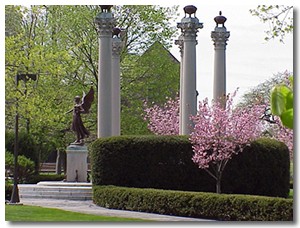
On Campus
Ball State has a nice campus to run. It has lots of paths that
let you cross the Quad and central campus many different ways,
with several arteries that connect the north, central, and south
parts of campus. I've run 5-6 miles on campus several times now
just by looping in and out for new views. McKinley Avenue is the
north-south artery that runs from near the football stadium on
the north to the Quad at the south. The south end of campus spans
to Tillotson Avenue on the west. It includes a soccer field where
you can run laps and Christy Woods, a small but scenic nature area
better known for holding hands and kissing than for running. I've
stayed at the Student Center hotel, which is simple and inexpensive,
and recommend it. Central campus runs east of McKinley and has
plenty of trees and paths.
Head east on either Riverside (past churches and frat row) or
University (through The Village, BSU's restaurant, club, and
store district) to find two areas of interest. When you reach
Wheeling Avenue, turn south and you will reach downtown Muncie
in no time. Even better, though, from Wheeling you can reach
either of the two nature trails that offer Muncie's best runs.
Delaware Greenways
Muncie offers two trail systems. You can find information on
both at
DelawareGreenways.org.
This
map of the trails
from that site shows the basic layout of the system, as well
as the Ball State campus and downtown Muncie, too.
The second stop in the Running on the Road series: Muncie, Indiana,
the home of
Ball State University.
(The first stop was
Allerton Park, Illinois.)
Ball State University is my alma mater, and I still have a place
in my heart for the university and for Muncie, its town. Muncie
is a typical small Midwestern city of about 80,000 people. It grew
up with the industrial expansion of the US in the early and middle
1900s and, like many such cities is not always pretty on the eyes.
But it is also typical Midwest in the friendliness and pride of
its people.
I was not a runner in college and so don't have any memories of
good routes. But I've been back to Muncie for various reunions
three of the last four years or so, which has led me to look for
and try out a few different places to run.
On Campus
Ball State has a nice campus to run. It has lots of paths that
let you cross the Quad and central campus many different ways,
with several arteries that connect the north, central, and south
parts of campus. I've run 5-6 miles on campus several times now
just by looping in and out for new views. McKinley Avenue is the
north-south artery that runs from near the football stadium on
the north to the Quad at the south. The south end of campus spans
to Tillotson Avenue on the west. It includes a soccer field where
you can run laps and Christy Woods, a small but scenic nature area
better known for holding hands and kissing than for running. I've
stayed at the Student Center hotel, which is simple and inexpensive,
and recommend it. Central campus runs east of McKinley and has
plenty of trees and paths.
Head east on either Riverside (past churches and frat row) or
University (through The Village, BSU's restaurant, club, and
store district) to find two areas of interest. When you reach
Wheeling Avenue, turn south and you will reach downtown Muncie
in no time. Even better, though, from Wheeling you can reach
either of the two nature trails that offer Muncie's best runs.
Delaware Greenways
Muncie offers two trail systems. You can find information on
both at
DelawareGreenways.org.
This
map of the trails
from that site shows the basic layout of the system, as well
as the Ball State campus and downtown Muncie, too.
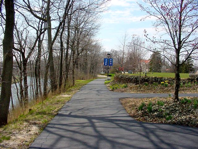 Coming from campus, when you hit Wheeling Avenue you reach the
White River Greenway,
which runs roughly west to east through town following the north
bank of the White River. I've only run the bit of this northeast
from Wheeling to the other trail, but I know that the river offers
a scenic view of some Muncie parks and residential areas. I'll
check it out more the next time I get to town.
Coming from campus, when you hit Wheeling Avenue you reach the
White River Greenway,
which runs roughly west to east through town following the north
bank of the White River. I've only run the bit of this northeast
from Wheeling to the other trail, but I know that the river offers
a scenic view of some Muncie parks and residential areas. I'll
check it out more the next time I get to town.
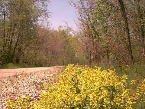 If you head south on Wheeling to Wysor Street and then turn left,
or north on the White River Greenway, you will reach the
Cardinal Greenway,
which is constructed on trackbed of the old Chesapeake and Ohio,
a railroad originally conceived to bring Appalachian coal to
Virginia tidewater. It runs 20 miles with Muncie in the middle,
though this rails-to-trails project aims to connect with another
C&O-based trail in eastern Indiana to reach 75 miles in length.
So far, I've only gone north from the
Wysor Street Trailhead,
at the site of a restored 1901 depot. The trail is marked every
half mile (excellent!) and has toilet facilities 4 miles north.
There is also a nice trailhead and parking lot at McGalliard
Avenue, a mile or so east of the north side of the Ball State
campus.
After a half mile or so, this trail is all natural, with lots
of green and farmland to view. I really enjoyed a 12-mile run
out and back on the trails this weekend. The southern portion
of the trail is probably pretty, too, as you'll be out of town
quickly. I plan to try it out next time!
-----
If you head south on Wheeling to Wysor Street and then turn left,
or north on the White River Greenway, you will reach the
Cardinal Greenway,
which is constructed on trackbed of the old Chesapeake and Ohio,
a railroad originally conceived to bring Appalachian coal to
Virginia tidewater. It runs 20 miles with Muncie in the middle,
though this rails-to-trails project aims to connect with another
C&O-based trail in eastern Indiana to reach 75 miles in length.
So far, I've only gone north from the
Wysor Street Trailhead,
at the site of a restored 1901 depot. The trail is marked every
half mile (excellent!) and has toilet facilities 4 miles north.
There is also a nice trailhead and parking lot at McGalliard
Avenue, a mile or so east of the north side of the Ball State
campus.
After a half mile or so, this trail is all natural, with lots
of green and farmland to view. I really enjoyed a 12-mile run
out and back on the trails this weekend. The southern portion
of the trail is probably pretty, too, as you'll be out of town
quickly. I plan to try it out next time!
-----